

[UPDATED DECEMBER 2023]
November 13th, 2019 was a big day for contemporary cartography. It was National GIS Day, and it proved to be a popular day on the internet for The Woodlands. For those who are unfamiliar with Geographic Information System (GIS) and National GIS Day, here’s the prompt from GIS: “GIS is a scientific framework for gathering, analyzing, and visualizing geographic data to help us make better decisions. Participate in the international celebration of geographic information systems (GIS) technology.”
The Woodlands is extremely fortunate to have a former volunteer turned staff member, Greg Fisher, leading our GIS efforts. Greg taught himself GIS and has applied the framework to digitize the historic maps and records of The Woodlands Cemetery. We first posted about his work on Facebook on GIS Day 2019, and it blew up on social. In honor of the Cemetery’s upcoming 180th Anniversary (back in 2020), we took an in-depth look into Greg’s transformative progress with GIS at The Woodlands.
As we approach 180 years since the foundation of The Woodlands Cemetery Company, I’d like to give you a sneak peak into the process of bringing historical cemetery maps and records into the 21st century. The Woodlands has maintained an electronic database of burial records since the early 2000s, but until now connecting this information to the physical space of the cemetery required manually cross referencing with lot cards and maps in both digital and physical forms. The solution to this problem is to use a geographic information system, or GIS for short. GIS software allows for the creation of digital maps that can store data about points or areas on the surface of the Earth. For The Woodlands, I’ve been using GIS to demarcate the boundaries of the cemetery’s sections and lots. Here’s a step-by-step walkthrough of how the process works.
Step 1 – Aerial Imagery
GIS projects are often built on top of a basemap to provide context for geospatial data. To create a map of The Woodlands, I needed a detailed picture of the site with clearly visible reference points. Fortunately, the City of Philadelphia provides a wealth of great GIS resources through OpenDataPhilly.org, including high resolution aerial photographs of the entire city. These images are clear enough for you to see individual monuments and even small lot marker stones – very useful for mapping!

The Woodlands as seen from above.

A group of headstones as seen from the ground.
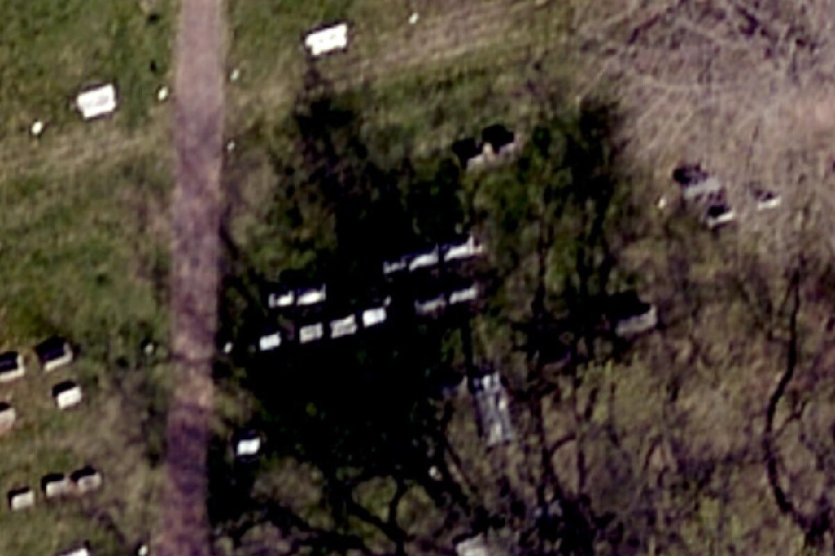
The same row seen in the aerial photos. Even the small stone marking the corner of the lot is clearly visible.
Step 2 – Georeferencing
In GIS, georeferencing is the practice of taking an object without a defined geographic location, such as a scanned paper map or an AutoCAD drawing, and determining its position in the physical world. Before I could begin laying out the lot boundaries, I needed to georeference the original cemetery plans to get a sense of where the lots were. This was done by matching landmarks on the map to the corresponding points in the aerial imagery. For example, the corners of the mansion are a very distinctive reference point. After completing this process the 19th century maps could be overlaid on top of the present day photographs to provide a guide for creating the lot map.
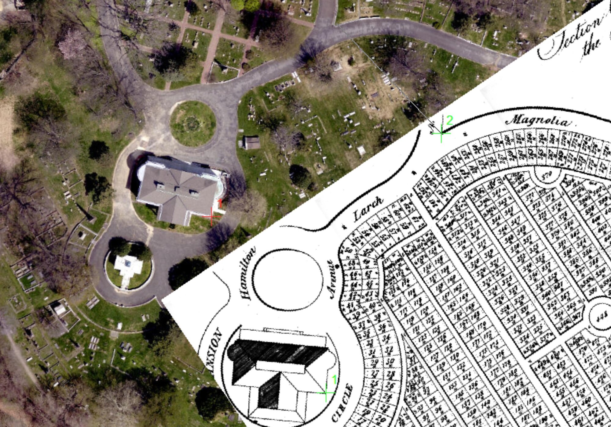
In this screenshot, you can see that I’ve match a point in a scanned map (the green 1) to the corresponding location in the aerial imagery (the red 1), and I’m in the process of matching another corner (green 2 and grey line). The GIS software uses these control points to scale and rotate the scanned image to the correct location.

Once georeferencing is complete, the scanned map can be laid on top of the aerial imagery.
Step 3 – Drawing the Lots
The most time-consuming part of the project was drawing the boundaries for the cemetery lots - over 5000 lots in total! This process is known as digitizing in GIS-speak, and involves tracing over georeferenced maps, comparing known distances to measurements in GIS, and matching features visible in aerial imagery to drawings of the lots found on our lot cards.

Sometimes digitizing is easy – here the stone coping around the lots makes drawing the border a piece of cake.

These lots are obscured by a tree, but since I know all of the lots in this row are 10’ by 16’, I can measure out the grid precisely.
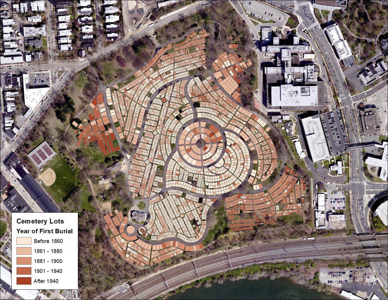
Step 4 – Connecting to Burial Records
Once the lot polygons were constructed, each one was labelled with its official lot number, which can then be used to associate it with our collection of lot cards and the burial records database. This is where the power of GIS can really be seen: being able to link burial records to a point on a map opens up many new avenues for visualizing the history of The Woodlands.
For example, here’s a map of the entire cemetery with the lots color-coded by the year of the first recorded burial. You can really see how the cemetery was filled in over the years, with the section C, D, and E in the core of the cemetery being used first and 20th century burials being concentrated in sections K and N in the northwest and southeast.
The Future
Going forward I’ll continue to work on improving the integration of the different datasets we have available. I’m excited to expand this project to include our collection of trees, and to connect the work I’ve done to The Woodlands Grave Gardener Program. Stay tuned for future updates on GIS at the Woodlands!